 Curry Rivel
WALK 5
CURRY RIVEL
A monument with spectacular views and Somerset moors
Steep descent and ascent to match, otherwise easy going
Distance 10.7 Km/ 6.7 miles
Total ascent/descent 107 m
www.mapmyrun.com/routes/view/18849076
Revised Jan 2024 Comments to [email protected]
1 From the bus-stop (GR392 252) in the centre of Curry Rivel (1) walk in the Taunton direction for 100m and turn R along Church Street, pass the school and turn L along Water Street. After 230m opposite a kissing gate, go L along a tarmac drive towards Waterstreet Farm and follow as it swings to the R to reach a waymarked gate. Go ahead 150m with a wall on the R to reach a slab stile at a crossing track. Cross the track, go through a gate and go ahead 150m with fence on L to reach another gate at a crossroads of paths. Continue ahead 200m to go through kissing gate on L and now go ahead along enclosed path to emerge at a road. Turn R and after 160m by wrought iron gates, go L down short path through kissing gate into large field. Bear slightly L keeping hedge on L for 250m to Bristol Gate and after 30m turn R along broad avenue of trees to the Burton Pynsent Monument (2) with views over much of the north of Somerset [2.0Km]
2 (GR377 252) Bear slightly L 100m down to a gate and descend along path, initially with wire fence on R, for 200m to reach a stile. Continue ahead 200m along the L edge of a large field to reach a lane and turn R to meander along the edge of West Sedge Moor for 1.4Km to reach a road [1.9Km]
3 (GR381 264) Turn L and after 600m pass the entrance to Oath Hill Farm and after a further 800m go across the new bridge over the railway and at junction turn R (SP Langport). Follow road passing Oath Lock (3) for 2Km to recross railway [3.6Km]
4 (GR400 272) After 270m just beyond the Wick entry sign and just before a house, go R (no sign) along Lakehouse Drove and follow for 800m to junction. Go L for 200m to farm buildings and then ascend gently 150m to sharp L bend then go R up very steep path 100m to reach a road by a telecoms tower. Go R and after 70m just before farm, go through gate on R and follow path 350m bearing L to a stile. Cross and go ahead with hedge on R for 100m then go R along waymarked path in front of house to reach track [1.8Km]
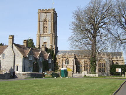
5. (GR392 262) After a few metres, just beyond the garage, go L through gate and along the L edge of field. After 250m at pedestrian gates continue ahead for 200m now with hedge on R, past barns to emerge at a T-junction of roads. Go straight ahead (Church Road) for 450m to reach St Andrew’s church (4), which is well worth a look if you have time, and then ahead to reach the main road and turn L to bus-stops [1.4Km]
FOR A SHORTER WALK Distance 3.9 Km/2.4 miles
Follow paragraph 1 to the Burton Pynsent Monument and admire view. Retrace your steps to the starting point.
For car travellers:
There is a large free car park on the right as you drive down Church Street.
Refreshments:
Firehouse, Church Street
1 The name Curry Rivel, comes from the Celtic word “crwy”, meaning boundary and “Rivel” from its 12th-century landlord Sir Richard Revel.
2 Burton Pynsent Monument is a 30m high classical column with lantern and cupola designed by Capability Brown and built in 1767 for William Pitt the Elder in honour of Sir William Pynsent, who had left him the Burton Pynsent Estate in thanks for Pitt's opposition to the imposition of a tax on cider. Occasionally, it is possible to climb to the top.
3 Oath Lock, originally built in the 1830s, marks the tidal limit of the River Parrett and is 31Km from the sea.
4 St Andrew’s church, Curry Rivel, was established by the time of the Domesday Book (1086) although most of the current building dates from the 15th Century apart from the tower, which was rebuilt in 1861.
2 (GR377 252) Bear slightly L 100m down to a gate and descend along path, initially with wire fence on R, for 200m to reach a stile. Continue ahead 200m along the L edge of a large field to reach a lane and turn R to meander along the edge of West Sedge Moor for 1.4Km to reach a road [1.9Km]
3 (GR381 264) Turn L and after 600m pass the entrance to Oath Hill Farm and after a further 800m go across the new bridge over the railway and at junction turn R (SP Langport). Follow road passing Oath Lock (3) for 2Km to recross railway [3.6Km]
4 (GR400 272) After 270m just beyond the Wick entry sign and just before a house, go R (no sign) along Lakehouse Drove and follow for 800m to junction. Go L for 200m to farm buildings and then ascend gently 150m to sharp L bend then go R up very steep path 100m to reach a road by a telecoms tower. Go R and after 70m just before farm, go through gate on R and follow path 350m bearing L to a stile. Cross and go ahead with hedge on R for 100m then go R along waymarked path in front of house to reach track [1.8Km]
5. (GR392 262) After a few metres, just beyond the garage, go L through gate and along the L edge of field. After 250m at pedestrian gates continue ahead for 200m now with hedge on R, past barns to emerge at a T-junction of roads. Go straight ahead (Church Road) for 450m to reach St Andrew’s church (4), which is well worth a look if you have time, and then ahead to reach the main road and turn L to bus-stops [1.4Km]
FOR A SHORTER WALK Distance 3.9 Km/2.4 miles
Follow paragraph 1 to the Burton Pynsent Monument and admire view. Retrace your steps to the starting point.
For car travellers:
There is a large free car park on the right as you drive down Church Street.
Refreshments:
Firehouse, Church Street
1 The name Curry Rivel, comes from the Celtic word “crwy”, meaning boundary and “Rivel” from its 12th-century landlord Sir Richard Revel.
2 Burton Pynsent Monument is a 30m high classical column with lantern and cupola designed by Capability Brown and built in 1767 for William Pitt the Elder in honour of Sir William Pynsent, who had left him the Burton Pynsent Estate in thanks for Pitt's opposition to the imposition of a tax on cider. Occasionally, it is possible to climb to the top.
3 Oath Lock, originally built in the 1830s, marks the tidal limit of the River Parrett and is 31Km from the sea.
4 St Andrew’s church, Curry Rivel, was established by the time of the Domesday Book (1086) although most of the current building dates from the 15th Century apart from the tower, which was rebuilt in 1861.
