 Glastonbury Tribunal
WALK 4
GLASTONBURY W
Historic Glastonbury,
moors and peat excavations
Easy level walking along tracks and droves
Distance 9.8 Km/ 6.1 miles
Total ascent/descent 22m
www.mapmyrun.com/routes/view/26615466
1 From the bus-stop (GR 499 388) go N along Magdalene St to the Market Cross and go R into High St to view three historic buildings on the L - after 50m the “George & Pilgrims”(1), then the Tribunal(2), and finally the Church(3). Return to the Cross and go R along Northload Street. After 90m at the end of the pedestrian section, go ahead and after 200m pass Sedgemoor Way on L then go immediately R along King St past Albert Buildings bearing L to a Fish & Chip shop at junction [0.8Km]
2 (GR497 393) Go L then R into St Brides Close and just beyond Manor Close go ahead along a tarmac track to reach a metal gate at a road. Cross with care and follow enclosed path 200m to cross wooden bridge then L (SP Footpath) past Abbey Moor Stadium to a road [0.6Km]
3 (GR494396) Cross the road and go ahead over a wooden bridge and keep the stream on the L. Continue for 1.5Km - with good views to L of the Mendip hills - past several Bristol gates, to reach farm buildings and sluice. Go L over bridge to reach road, go R for 100m then turn L along the road to Sharpham [1.6Km]
4 (GR480 401) After 300m go R (Surface Deformed), passing peat excavations(4) on the L. After 800m follow as it bends 900 L and continue for 600m past a brightly painted house to another 900 L bend. After 800m passing more peat excavations reach a junction. Go R past the post box and after a few steps cross the course of the former Glastonbury to Highbridge railway line(5) . Continue 1Km to Durstons junction [3.6Km]
5 (GR469 384) Go ahead for 60m then L (SP Public Footpath) over stile. Go between lakes and where path bends R around lake, go ahead across sleeper bridge and continue with water on L to reach buildings. Continue along tarmac track to reach a road, turn L and after 50m go R into Porchestall Drove. Follow for 1.2km ignoring a turn on the L by the pumping station and passing a large timber storage depot to reach a mini-roundabout. [2.4Km]
6 (GR491 388) Continue into Park Farm Road and at the main road go across pedestrian crossing, then turn R between two brick walls, then L passing Scout hut and tennis courts on the R. Go ahead at Give Way sign and at St Benedict’s church, fork L to reach the Cross. The bus-stops are R, that for Somerton and Yeovil being across the road[0.8Km]
FOR A SHORTER WALK Distance 3.0 Km/ 1.9 miles
Follow to the end of point 2. At the road turn L for 40m to another junction. Turn R, cross the bridge and go L along Dyehouse Lane (no sign). Keep water on L for 400m and follow as the road zig-zags over a bridge then a further 200m to reach a roundabout. Continue ahead for 200m to reach the mini-roundabout at the end of point 5 then go L into Park Farm Road (point 6).
For car travellers:
On-street parking is available 250m along Benedict St, (the return route). Walk up past St Benedict’s to the Market Cross
Refreshments:
Many options in Glastonbury
1 The George Hotel and Pilgrims' Inn was built in the late 15th century to accommodate visitors to the Abbey.
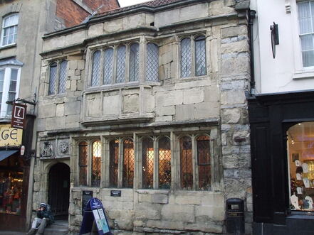
2 The Tribunal was built in the 15th century as a merchant's house, and later used as the Abbey courthouse and by Judge Jeffreys.
3 The Church of St John the Baptist dates from the 15th century and is laid out in a cruciform plan with an aisled nave and a clerestory of seven bays. The interior includes four tomb-chests, and some stained glass from the 15th century.
4 Peat extraction is known to have taken place during Roman times, and has been ongoing since although now it is considered unsustainable 5The Glastonbury to Highbridge line opened in August 1854 and was planned to be part of a link from Burnham to Poole. It was operated by the Somerset & Dorset railway company. The last passenger train ran in March 1966. The final traffic brought foundation materials for M5 motorway.
2 (GR497 393) Go L then R into St Brides Close and just beyond Manor Close go ahead along a tarmac track to reach a metal gate at a road. Cross with care and follow enclosed path 200m to cross wooden bridge then L (SP Footpath) past Abbey Moor Stadium to a road [0.6Km]
3 (GR494396) Cross the road and go ahead over a wooden bridge and keep the stream on the L. Continue for 1.5Km - with good views to L of the Mendip hills - past several Bristol gates, to reach farm buildings and sluice. Go L over bridge to reach road, go R for 100m then turn L along the road to Sharpham [1.6Km]
4 (GR480 401) After 300m go R (Surface Deformed), passing peat excavations(4) on the L. After 800m follow as it bends 900 L and continue for 600m past a brightly painted house to another 900 L bend. After 800m passing more peat excavations reach a junction. Go R past the post box and after a few steps cross the course of the former Glastonbury to Highbridge railway line(5) . Continue 1Km to Durstons junction [3.6Km]
5 (GR469 384) Go ahead for 60m then L (SP Public Footpath) over stile. Go between lakes and where path bends R around lake, go ahead across sleeper bridge and continue with water on L to reach buildings. Continue along tarmac track to reach a road, turn L and after 50m go R into Porchestall Drove. Follow for 1.2km ignoring a turn on the L by the pumping station and passing a large timber storage depot to reach a mini-roundabout. [2.4Km]
6 (GR491 388) Continue into Park Farm Road and at the main road go across pedestrian crossing, then turn R between two brick walls, then L passing Scout hut and tennis courts on the R. Go ahead at Give Way sign and at St Benedict’s church, fork L to reach the Cross. The bus-stops are R, that for Somerton and Yeovil being across the road[0.8Km]
FOR A SHORTER WALK Distance 3.0 Km/ 1.9 miles
Follow to the end of point 2. At the road turn L for 40m to another junction. Turn R, cross the bridge and go L along Dyehouse Lane (no sign). Keep water on L for 400m and follow as the road zig-zags over a bridge then a further 200m to reach a roundabout. Continue ahead for 200m to reach the mini-roundabout at the end of point 5 then go L into Park Farm Road (point 6).
For car travellers:
On-street parking is available 250m along Benedict St, (the return route). Walk up past St Benedict’s to the Market Cross
Refreshments:
Many options in Glastonbury
1 The George Hotel and Pilgrims' Inn was built in the late 15th century to accommodate visitors to the Abbey.
2 The Tribunal was built in the 15th century as a merchant's house, and later used as the Abbey courthouse and by Judge Jeffreys.
3 The Church of St John the Baptist dates from the 15th century and is laid out in a cruciform plan with an aisled nave and a clerestory of seven bays. The interior includes four tomb-chests, and some stained glass from the 15th century.
4 Peat extraction is known to have taken place during Roman times, and has been ongoing since although now it is considered unsustainable 5The Glastonbury to Highbridge line opened in August 1854 and was planned to be part of a link from Burnham to Poole. It was operated by the Somerset & Dorset railway company. The last passenger train ran in March 1966. The final traffic brought foundation materials for M5 motorway.
