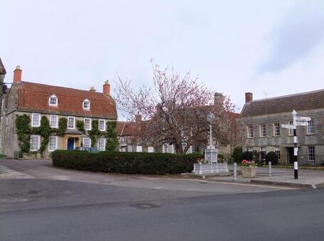
 Cow Square & the Old Hall
WALK 9
SOMERTON & KINGSDON WOODS
The former capital of Wessex
with its fine historic buildings
Easy walking on tracks and lanes -
maybe slippery when wet
Distance 10.3 Km/ 6.4 miles
Total ascent/descent 156m
www.mapmyrun.com/routes/view/25044576
Updated July 2023 Comments to [email protected]
1 From the bus-stop (GR 491 285), do take time to visit St Michael’s Church(1) just across the road. Then walk past the Buttercross(2) and follow the road as it bears L into Broad Street, an avenue of lime trees. Pass several interesting old houses and after 100m reach Cow Square with its restored horse trough and overlooked by The Old Hall. Turn R along New Street(3) and follow for 200m and just beyond Hillhead Cottage go R through a metal squeeze, ascend steps and follow the tarmac path to emerge in The Millands with its open grass area in the centre. Go L, follow clockwise and just beyond number 20, go L along path to a kissing gate to a field. Bear 45 degrees R to a stile in the fence, cross and descend with hedge on R. through gate and along a short track to reach a road [1.0Km]
2 (GR497 283) Go L 150m to reach the busy B3151. Cross with care, go L for 35m then go R. Follow for 900m past The Mill(4) and Somerton Randle(5) to reach a gate and stile on R (this is the return route) [1.0Km]
3 (GR506 283) Continue ahead for a further 750m and at the end of the tarmac, go R through wooden squeeze and follow clear path keeping hedge on L for 160m to reach a hedge gap. Bear slightly L and continue, still with hedge on L, to reach woods. Ascend the obvious track and after 500m on emerging from woods follow clear track across field to reach a metal gate at a road [1.8Km]
4 (GR508 272) Go L along road 100m with great care (if passable go inside hedge) and then L to locate path through wooded area with hedge on L. After 250m the path bears L away from road and soon becomes a wide track. Follow for 750m to a cross-roads of tracks. Go sharp L (waymarked Bridleway) for 700m and follow as track bears sharp L into Kingsdon woods. Ignore L turn after 100m and follow as track descends, gently at first then more steeply (there is an easier parallel path approx 5m to the R) to reach a tarmac road. Follow 750m to gate on the L at the end of point 2 [3.3Km]
5 GR(506 283) Go through gap and bear 45 degrees L then bear R to gates at wooded area then sharp R and follow path just in the woods, with a wire fence on L for 550m to emerge in a field. Continue ahead through large hedge gap and cross field on well-defined track to cross sleeper bridge into the next field. Follow obvious track bearing slightly L via two kissing gates to road [1.0Km]
6 (GR499 278) Go straight ahead with care for 100m and where road bears sharp L, cross and take road on R (7.5t weight limit) past Keepers Cottage. Go ahead at crossroads and continue for 350m then go R through Bristol gate (SP Footpath). Keep hedge on R 400m then enter enclosed track to a T-junction of tracks. Go R and after 100m through gate and bear 45 degrees L to follow obvious track across field to cross a stile and continue to a stone stile to road. Go L 50m then R at mini-roundabout up Parsonage Hill. At the top by Police Station, go L along Kirkham Street to the Market Place(6) and bus-stop [2.2Km]
Note: Buses operate a one-way system, so all buses pass this stop
FOR A SHORTER WALK Distance 5.3 Km/ 3.2 miles
Follow route to the gate at the end of point 2. This is the start of point 5. Follow back to Somerton.
For car travellers:
Free parking is available in Broad St or Market Place
Refreshments:
Cafés/pubs in Somerton
1 St Michael & All Angels church dates from the 13th century and is Grade I listed. Inside is one of the finest wooden carved roofs in the county dating from about 1450.
2 The Buttercross was built in 1673 by the Hext family at a cost of £300 although there was an earlier cross on the site. It belonged to the Earls of Ilchester until they could not afford to repair it after World War I, when it was given to the town.
3 New Street (probably the oldest street in the town!) has many old buildings including the Grade II listed Cockspurs, the site of a former cock-fighting ring.
4 Somerton Mill first recorded 1513 and continued as a mill until 1935. It is listed Grade II*
5 Somerton Randle a large 18th century detached house remodelled in 1846. It is listed Grade II
6 The Market Place contains many interesting buildings and was the backdrop for the BBC drama “The Monocled Mutineer” (1985/6).
