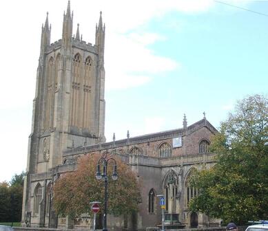
 St Cuthbert's Church, Wells
WALK 1
WELLS NW
England’s smallest city, the Mendips and Ebbor gorge
Fabulous views but not for the faint-hearted – a tough walk!
Distance 12.5 Km/7.5 miles
Total ascent/descent 269m
www.mapmyrun.com/routes/view/21523112
Updated October 2023 Comments to [email protected]
1 From the bus-stop at Wells bus station (GR546 456) bear R along road beside a taxi stand and go L through metal railings then turn R (SP Cathedral). At the end of street, go L and after 50m go L (SP St Cuthbert’s Church(1). Just before church go R into Priest Row (but pause to look inside church), pass almshouses on R and at end go over pedestrian crossing then go L and immediately R into Whiting Way. At traffic lights, go R on tarmac path 150m past skate park and fork L to cross footbridge over road and continue ahead on path through grounds of the Blue School(2). Just beyond building named ‘Barkham’ go ahead through metal gate and follow tarmac path to reach road. Cross and go up steps slightly to L along path, ascending steadily to another road. Cross and go ahead to another road [1.5Km]
2 (GR543 467) Go sharp R descend 70m then L into Reservoir Lane. After 250m continue ahead on track, ignoring L turn, to ascend though woods. Cross stile to R of metal gate and continue with fence on L to road. Go R for 300m[1.1Km]
3 (GR549 472) Just before R bend go L up track (SP Bridleway) ascending steeply at first. After 1Km bear sharp L with track and descend 250m to reach road. Go R uphill 400m with care then L over stone stile by metal gate with fingerpost. Ascend VERY steeply for 200m with fence on L to stile [1.8Km] [If steepness deters go a further 500m up road then L along tarmac road (no sign). Bear L after 350m to reach the stile in 100m]
4 (GR547 487) Cross and go L along a track with terrific views. After 250m by cattle grid go L following fingerpost to L end of hawthorn hedge. Bear R to Bristol gate and then bear slightly R to top of hill to locate a waymarked stile ahead. Go ahead 300m parallel to wall and at next stile go ahead with hedge on R. After 250m at crossing hedge go ahead 300m to cross stile and a further 70m to reach metal gate [1.7Km]
5 (GR532 488) Just before gate go L and follow 200m with hedge on R to a stile and enter the Ebbor Gorge(2) Reserve. Continue 300m on broad track to “Cliff Edge Ahead” sign and go ahead 100m for view into Ebbor Gorge. Return to sign and go R (SP Car park) down stepped path 600m to junction. Go L (SP Wookey Hole) and at gate exit Ebbor Gorge Reserve and go along grassy track to road [1.9Km]
6 (GR528 478) Go L descending gently through Wookey Hole. After 750m just beyond Milton Lane, go through waymarked gate on L and follow 350m with hedge on R as it bears R and passes through two kissing gates to reach a tarmac track. Go L and follow for 800m ascending gently then descending steeply to junction just beyond metal gate. Go R for 300m to metal gate and after 50m where road goes L, ahead into track (SP Wells) [2.2Km]
7 (GR543 467). Follow path across three roads through Blue School and over bridge. Just beyond skate park go L along tarmac track to join road and where it bears L, go R then L to reach New St. Go R 70m and sharp L at mini roundabout. After 200m go R through narrow passage to go down Vicar’s Close(4). At end go under arch and go R past cathedral and under arch to Sadler St. Go L and at Market Place go R down High St, By City Arms go L into Queen St then R into Market St to reach bus station [2.3Km]
FOR A SHORTER WALK Distance 3.1 Km/ 1.9 miles
Follow to end of point 1. Turn round and follow from point 7.
For car travellers:
On-street parking is free on Sundays, otherwise car park in Whiting Way (paragraph 1).
Refreshments:
Cafés/pubs in Wells
Cafés/pubs in Wookey Hole
1 St Cuthbert’s has the third highest church tower in Somerset (43m) and 16th Century nave ceiling repainted in 1963. The pulpit dates from 1636 and the reredos from 13th Century
2 The Blue School is a coeducational, secondary school, founded in 1654 as one of the first free schools in the country. It has about 1,500 students
3 Ebbor Gorge is a 63.5 hectares (157 acres) limestone gorge and a Site of Special Scientific Interest. Caves were inhabited by Neolithic people.
4 Vicar’s Close a street of 14th Century houses, many Grade I listed, said to be the oldest of its type in Europe
Parts of this route follow the West Mendip Way, a superb 30 mile trail from Weston-super-Mare to Wells
2 (GR543 467) Go sharp R descend 70m then L into Reservoir Lane. After 250m continue ahead on track, ignoring L turn, to ascend though woods. Cross stile to R of metal gate and continue with fence on L to road. Go R for 300m[1.1Km]
3 (GR549 472) Just before R bend go L up track (SP Bridleway) ascending steeply at first. After 1Km bear sharp L with track and descend 250m to reach road. Go R uphill 400m with care then L over stone stile by metal gate with fingerpost. Ascend VERY steeply for 200m with fence on L to stile [1.8Km] [If steepness deters go a further 500m up road then L along tarmac road (no sign). Bear L after 350m to reach the stile in 100m]
4 (GR547 487) Cross and go L along a track with terrific views. After 250m by cattle grid go L following fingerpost to L end of hawthorn hedge. Bear R to Bristol gate and then bear slightly R to top of hill to locate a waymarked stile ahead. Go ahead 300m parallel to wall and at next stile go ahead with hedge on R. After 250m at crossing hedge go ahead 300m to cross stile and a further 70m to reach metal gate [1.7Km]
5 (GR532 488) Just before gate go L and follow 200m with hedge on R to a stile and enter the Ebbor Gorge(2) Reserve. Continue 300m on broad track to “Cliff Edge Ahead” sign and go ahead 100m for view into Ebbor Gorge. Return to sign and go R (SP Car park) down stepped path 600m to junction. Go L (SP Wookey Hole) and at gate exit Ebbor Gorge Reserve and go along grassy track to road [1.9Km]
6 (GR528 478) Go L descending gently through Wookey Hole. After 750m just beyond Milton Lane, go through waymarked gate on L and follow 350m with hedge on R as it bears R and passes through two kissing gates to reach a tarmac track. Go L and follow for 800m ascending gently then descending steeply to junction just beyond metal gate. Go R for 300m to metal gate and after 50m where road goes L, ahead into track (SP Wells) [2.2Km]
7 (GR543 467). Follow path across three roads through Blue School and over bridge. Just beyond skate park go L along tarmac track to join road and where it bears L, go R then L to reach New St. Go R 70m and sharp L at mini roundabout. After 200m go R through narrow passage to go down Vicar’s Close(4). At end go under arch and go R past cathedral and under arch to Sadler St. Go L and at Market Place go R down High St, By City Arms go L into Queen St then R into Market St to reach bus station [2.3Km]
FOR A SHORTER WALK Distance 3.1 Km/ 1.9 miles
Follow to end of point 1. Turn round and follow from point 7.
For car travellers:
On-street parking is free on Sundays, otherwise car park in Whiting Way (paragraph 1).
Refreshments:
Cafés/pubs in Wells
Cafés/pubs in Wookey Hole
1 St Cuthbert’s has the third highest church tower in Somerset (43m) and 16th Century nave ceiling repainted in 1963. The pulpit dates from 1636 and the reredos from 13th Century
2 The Blue School is a coeducational, secondary school, founded in 1654 as one of the first free schools in the country. It has about 1,500 students
3 Ebbor Gorge is a 63.5 hectares (157 acres) limestone gorge and a Site of Special Scientific Interest. Caves were inhabited by Neolithic people.
4 Vicar’s Close a street of 14th Century houses, many Grade I listed, said to be the oldest of its type in Europe
Parts of this route follow the West Mendip Way, a superb 30 mile trail from Weston-super-Mare to Wells
FOR A SHORTER WALK Distance 4.1 Km/ 2.5 miles
Follow to end of point 1. Turn round and follow from point 7.
Follow to end of point 1. Turn round and follow from point 7.
For car travellers:
On-street parking is free on Sundays, otherwise car park in Whiting Way (paragraph 1).
On-street parking is free on Sundays, otherwise car park in Whiting Way (paragraph 1).
Refreshments:
Cafés/pubs in Wells
Cafés/pubs in Wookey Hole
Cafés/pubs in Wells
Cafés/pubs in Wookey Hole
1 St Cuthbert’s has the third highest church tower in Somerset (43m) and 16th Century nave ceiling repainted in 1963. The pulpit dates from 1636 and the reredos from 13th Century
2 The Blue School is a coeducational, secondary school, founded in 1654 as one of the first free schools in the country. It has about 1,500 students.
3 Ebbor Gorge is a 63.5-hectares (157 acres) limestone gorge and a Site of Special Scientific Interest. Caves were inhabited by neolithic people.
4 Vicar’s Close a street of 14th century houses, mostly Grade I listed, claimed to be the oldest of its type in Europe
Parts of this route follow the West Mendip Way, a superb 30 mile trail from Weston-super-Mare to Wells
2 The Blue School is a coeducational, secondary school, founded in 1654 as one of the first free schools in the country. It has about 1,500 students.
3 Ebbor Gorge is a 63.5-hectares (157 acres) limestone gorge and a Site of Special Scientific Interest. Caves were inhabited by neolithic people.
4 Vicar’s Close a street of 14th century houses, mostly Grade I listed, claimed to be the oldest of its type in Europe
Parts of this route follow the West Mendip Way, a superb 30 mile trail from Weston-super-Mare to Wells
