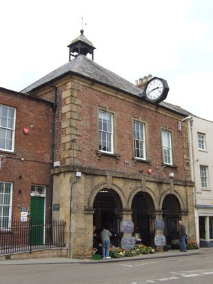
 Town Hall, Langport
WALK 7
LANGPORT
Spectacular views over the Parrett valley and Somerset
Many stiles, a very steep ascent and a steep descent
Distance 10.2 Km/6.3 miles
Total ascent/descent 115 m
www.mapmyrun.com/routes/view/19827178
Revised July 2023 Comments to [email protected]
1 From the bus-stop (GR 419 268) by the Town Hall, go along the parade of shops at 90 degrees to the road and at the end turn R through car park to reach a gate. Go along the gravel path joining the river and bear R. At the pedestrian bridge do not cross, but bear R (SP Gt Bow Wharf) then L and at the road go R, over pedestrian crossing and after 140m by old petrol pump, L into Moor Lane (SP Parrett Trail(1). At gate, go L 150m up to the river bank then R 450m under the metal bridge and follow river 800m to Monk’s Leaze Clyse(2) [2.2Km]
2 (GR409 276) Bear L through two metal gates and continue with river on the L for 800m. Just beyond a Bristol gate, turn R (SP Aller), go over the Sowy River through a second Bristol gate and continue for 1Km with a rhyne on the R through a copse and passing two “tilting sluices” to reach a bridge on the R. Do not cross, but go ahead 100m through a Bristol gate and turn 90 degrees L (SP St Andrew’s Church), aiming slightly L of the tower to reach two gates into the churchyard [2.3Km]
3 (GR396 288)Take the path to the L - pausing to look inside the church(3) - to reach a gate on to a road and turn R. Follow the road 300m and just beyond the recreation ground do not turn R, but fork R along the enclosed path (SP Public Footpath). When the path joins a road, go ahead 200m to junction by the pub in Aller. Turn L along Ridley Hill and after 150m at Croft House, cross the road with care and go ahead 20m up steep tarmac drive to footpath on the L (SP Aller Hill). After steep climb to tarmac road go R continue climbing and when tarmac ends by Spring Cottage, go ahead into a muddy track [1.5Km]
4 (GR404 294) Where the track bears L, locate a stile on the R and follow the clear path 1Km firstly between fences, then through a wooded area then along the ridge with a boundary on L to reach a caravan park. Keep hedge on L 200m and at end of field, do not bear R downhill, but go ahead through the edge of woods. Just after the next stile stop to admire the terrific panorama and after 50m cross the stile on the L, then turn R and continue, now with the hedge on the R 100m to a stile, after which bear L to reach a metal gate to the L of a small telecoms tower. Through the gate turn R along the road for 50m and take a path on R (SP Public Footpath) to pass a disused quarry and descend steeply along the edge of woods to wooden steps descending to a road [1.8Km]
5 (GR415 283) Cross this busy road with great care to the lane opposite (SP Combe). After 130m bear L, then 100m bear L again by Combe House Farm and after 200m opposite the Bally Coombe driveway go through gate on R into a field. Keep hedge on R, continue ahead at gate and soon join a stream on the R and follow 800m keeping stream on R to reach 2 gates, a small sleeper bridge and 2 double stile/sleeper bridges and then bear R across larger bridge [1.4Km]
6 (GR416 273) Just before the metal railway bridge, bear L and follow the railway embankment on R then pass under the third arch of the blue brick bridge and bear L. Continue 400m with rhyne on L to reach a footbridge on L and cross to reach a supermarket car park. Go ahead to reach the road, turn R and follow past some interesting buildings and bear R into Bow Street to reach Langport(4)Town Hall and the bus-stop [1.0Km]
FOR A SHORTER WALK Distance 3.3 Km/2.0 miles
Follow as far as point 2, then retrace your steps to the metal railway bridge at point 6 and continue to the end.
For car travellers:
There is a large free car park at the end of the shopping parade in the centre of Langport.
Refreshments:
Cafés in Langport
Langport Arms Hotel
Black Swan Inn, Langport
Old Pound Inn, Aller
1 The River Parrett Trail is a long distance path following the river for 80km(50miles) from Cheddington in Dorset to Bridgwater Bay
2 Monk’s Leaze Clyse regulates the flow of water between the River Parrett and the Sowy River - retaining water in summer and controlling flooding in winter.
3 St Andrew’s church was established in 878 and rebuilt in stone about 1166. The building is mostly14th century, but there are Norman fragments.
4 Langport is mentioned in the Domesday Book. In 1645 the Battle of Langport was the last in the Civil War. Stuckey’s Bank was founded here in 1770 and by 1909 had the second highest banknote circulation after the Bank Of England.
