 Hood Monument
WALK 8
COMPTON DUNDON
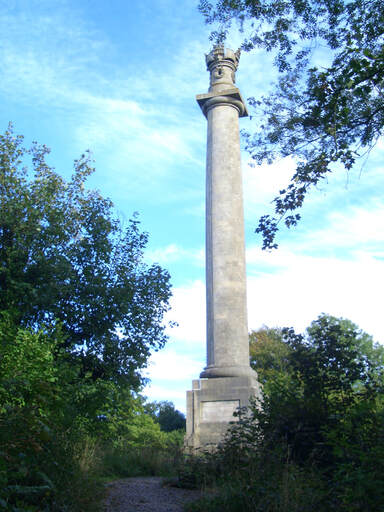
The Hood Monument
and a path of flagstones
Tracks and lanes with ups and downs
and magnificent views
Distance 10.6 Km/6.6 miles
Total ascent/descent 218m
www.mapmyrun.com/routes/view/23807416
Updated February 2023 Comments to [email protected]
1 From the bus-stop(GR489 328) go to the war memorial and go west along Compton St. After 180m at Corner Cottage bear R passing Corner Farm and after 130m reach junction [0.3Km]
2 (GR492 328) Go ahead for 30m then L on track (SP Restricted Byway) gently ascending. After 450m go L at fork to enter wooded area. There are several paths, but keep to side of valley, generally ascending, for 900m to reach crossing track [1.3Km]
3 (GR505 327) Go L up stepped path (SP Polden Way) to kissing gate. (Follow the Polden Way to the end of point 4). Bear L and follow path ascending gently 150m to junction. Go ahead for 350m to picnic site then go sharp R - but go ahead for 100m for a great view and a carved wood chair. After 300m reach a cross-roads of tracks. Bear L down steps and follow pleasant woodland path ignoring L and R turns. At kissing gate, keep post and wire fence on R to reach open field with good views. Go ahead along broad grassy swathe. Go L over stile through gate and along undulating path to the Hood Monument(1) with good view to Glastonbury Tor. Go past monument on L and down track to a road. Go R for 20m then L (SP Public Footpath) [2.2Km].
4 (GR494 339) Follow well-defined path towards the ridge with excellent views to the L. Later, join a post and wire fence on the R with wide views ahead as far as the Brecon Beacons. Descend gently to reach gate at road junction [1.1Km]
5 (GR485 345) Go straight across with care, up narrow path and immediately L along the narrow unsignposted lane and follow as it meanders gently down passing Ivythorn Manor(2). After 500m at gate, continue ahead 200m to a crossing track. Go ahead over stile, keeping hedge on L and after 250m just before end of field, go L over waymarked stile and sleeper bridge and follow, now with ditch/hedge on R to cross stile to L of metal gate. Continue with hedge on L for 200m and cross stile on L to reach track. Go R for 800m to Give Way sign at crossroads by cricket pitch [2.0Km]
6 (GR480 327) Go R (Hayes Rd), follow for 1.2Km and at house called Orchard End, go L up short track to gate then ascend steeply with hedge on L to gate and sleeper bridge. Go L and ascend 300m with hedge on L to pedestrian gate. A few metres beyond go 45 degrees R up faint path to trig point on Lollover Hill(3) for far-reaching views. Go 90 degrees L and descend faint path (may be slippery) to join track by gate. Follow track for 350m follow as it bears R and then go L down steps and along path to reach road. Go L and bear to R by No Through Road sign (but go ahead to visit church(4) then R into School Lane [2.5Km]
7 (GR480 325) Follow to end of tarmac then go ahead along track with flagstones(5). Go through two kissing gates and continue along flagstones through more gates and a farmyard to reach a road. Turn R for 350m to the main road and bus-stop - for Wells on the R and for Somerton &Yeovil across the road [1.2Km]
FOR A SHORTER WALK (1) Distance 5.2 Km/3.2 miles
Follow to the end of point 3. Go L along road for 700m. At junction turn R for 70m then L along Compton Street for 500m and follow as it bears R by Corner Cottage 180m to reach war memorial and bus-stop.
FOR A SHORTER WALK (2) Distance 5.7 Km/3.5 miles
Follow to junction at the end of point 1. Go L for 1.1Km climbing steadily. Just beore junction reach start of point 4. Take path on L and follow to end of point 5. Go L and follow to village and bus-stop.
FOR A SHORTER WALK (3) Distance 4.6 Km/2.9 miles with steep climb
From the bus stop head east along Ham Lane 900m to crossroads by cricket pitch. Go ahead into Hayes Road and follow from point 6.
For car travellers:
Park in Compton St or close to the memorial with consideration or (with permission) at the Castlebrook Inn.
Refreshments:
Castlebrook Inn
1 The Hood monument is a 34m high Tuscan column erected in 1831 by public subscription as a memorial to Vice Admiral Sir Samuel Hood RN (1762-1814).
2 Ivythorn Manor was rebuilt in 1488 for the Abbot of Glastonbury and restored 1904. It is listed Grade II*
3 Lollover Hill is 90 meters high and commands views over most of Somerset
4 St Andrew’s has a 16th Century font and a 17th Century pulpit.
5 Flagstones between church and village are the remains of a path to save parishioners from wet feet!
