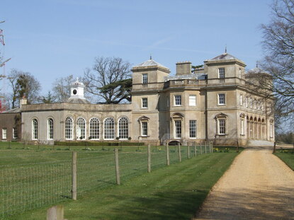
 Hatch Court
WALK 3
WRANTAGE (CANAL INN)
A disused canal, Hatch Court and some superb views
An all weather walk, but best when visibility is good
Distance 10.5 Km/6.5 miles
Total ascent/descent 112m
www.mapmyrun.com/routes/view/18459072
Revised January 2024 Comments to [email protected]
1 From the bus-stop (GR308 225) by the Canal Inn go W (towards Taunton) 600m passing the large lay-by. Just beyond Barcroft Cottage, turn R down a broad grassy track behind houses. After 200m cross a footbridge, bear L and continue with the stream on L for 200m to reach a stile by a bridge which carried the Chard Canal(1) across the stream. Continue to follow the stream round the edge of field for 500m then cross a small footbridge on L just before a tree. Go ahead now with hedge on R and after 300m just before the copse go R along track and follow bearing L round the copse to reach a road in Lillesdon [2.1Km]
2 (GR303 235) Turn L and follow the road for 600m to a bridge crossing the Chard Canal(1).. If time, go R over stile (SP Public Footpath) to view the canal on the R. Continue along the road for 450m to the A378 [1.0Km]
3 (GR300 225) Cross the road with great care to the road directly opposite (SP Meare Green). Follow for 330m then go L opposite The Elms along a track (SP Public Footpath). After 30m bear R between hedge and fence and follow enclosed path. After 250m cross stile and bear slightly R across field 250m aiming to L of trees to a waymarked Bristol gate. Cross stream, go through another Bristol gate then bear R 200m to far corner with two gates. Take the waymarked R Bristol gate and go L with hedge on L for 70m and go through Bristol gate on L. Follow 500m now with hedge on R as it bears L then R and at next corner head for metal gate in far corner to reach a road (it may be easier to walk round the edge with hedge on R) [1.7Km]
4 (GR298 212) Do not follow the road, but turn L to follow a drive with a concrete post-and-wire fence on L. After 60m follow the fence as it bears L and after 100m R to cross a waymarked bridge. Go through the edge of the garden with stream on L to locate another gate then R to another gate. Here go sharp L with fence on L through two more gates to road by Picketmead. Turn R and follow 450m until it passes under the old railway bridge. Turn L and follow for 400m to crossroads by the Hatch Inn[1.0Km]
5 (GR302 206) Go R, follow for 450m and at Ashdale House go L to Bristol gate and cross field 200m to far corner, then go L with hedge on L. After 120m, ignore gate on L but bear 45 degrees R along path past sewage works on R. Aim for hedge corner, then bear L to kissing gate to road. Go L for 630m to the Hatch Inn [1.7Km]
6 (GR302 206) Go R (SP Church) and after 400m L along concrete drive passing Hatch Court2 on the R. At the end of drive pass church(3) and car-park and through waymarked gate to pass between the church and a house, along grassy track to reach a concrete drive. Cross and follow the waymarked path on L aiming for a gap in the hedge, to reach a short track and road. Go ahead for 750m to reach a T-junction [2.0Km]
7 (GR314 219) Just before junction, go L down grassy track SP Wrantage, then 100m along short track and stile to emerge in a field at the top of Crimson Hill with terrific views. Continue passing to L of first pillbox(4) down steep steps then across a field to cross a stile. On R can be seen tank stops(4) and the overgrown tunnel(5) entrance of the Chard Canal. Continue ahead through gate and down the track. At the road go R for 100m to the bus-stop [1.0Km]
FOR A SHORTER WALK Distance 5.1 Km/3.2 miles
From the start go to the large lay-by, cross the road and go along Oldway Lane to emerge at the bridge in point 4 then go L along road 400m to the Hatch Inn.
Go L (SP Church) and follow from point 6
For car travellers:
There is a large lay-by on the north side of the A378 200m in the Taunton direction from the Canal Inn.
Refreshments:
Canal Inn, Wrantage
Hatch Inn, Hatch Beauchamp
1 Chard Canal, part of a plan to link the Bristol Channel with the English Channel opened 1842, went into receivership 1853 and closed 1866
2 The bridge and the station served a branch line from Chard Junction to Taunton which opened in 1866 and closed in 1962.
3 Hatch Court is a Palladian mansion built of Bath stone in 1750 by Thomas Prowse of Axbridge, for John Collins. It is listed Grade I
4 St John the Baptist originates in the Norman period, but the tower was built in 1500. It is listed Grade I
5 Pillboxes and tank stops were part of the 1940 Taunton Stop Line, from the north Somerset coast to Seaton (Devon), to deter a tank attack from the west.
6 In its short length of 22Km the Chard canal had four aqueducts four inclined planes and three tunnels!
