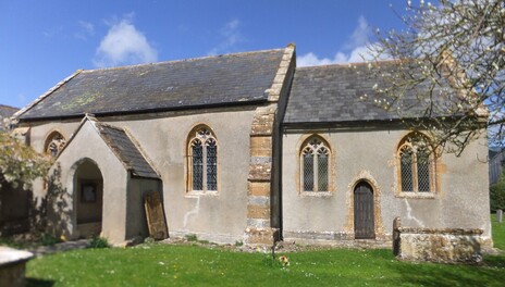
 St Catherine's Church, Swell
WALK 4
FIVEHEAD
An ancient church, country lanes, droves and the R Isle
Easy walking but droves may be muddy
Distance 11.5 Km/7.1 miles
Total ascent/descent 58 m
www.mapmyrun.com/routes/view/18533764
Updated July 2023 Comments to [email protected]
FIVEHEAD
An ancient church, country lanes, droves and the R Isle
Easy walking but droves may be muddy
Distance 11.5 Km/7.1 miles
Total ascent/descent 58 m
www.mapmyrun.com/routes/view/18533764
Updated July 2023 Comments to [email protected]
1 From the bus stop (GR352 233), walk east (towards Langport) for 70m and turn R down Butchers Hill. After 450m at junction by Baptist Church, turn L (SP Isle Brewers). At T-junction just beyond Old Post Office, continue ahead (SP Swell) and after a sharp L bend continue for 350m past Langford Manor to reach track on R (SP Swell Drove ½m). After 800m at Swell Drove T-junction, turn R and after 500m reach a road [2.5Km]
2 (GR356 222) Go L (SP Isle Brewers) and after 1Km pass the Isle Brewers entry sign and cross bridge over the River Isle. Cross a second bridge, enter the village and just before the village green with willow trees and Millennium stone, turn R and follow road for 350m [1.8Km]
3 (GR365 209) After 350m where road bears sharp R, go ahead on waymarked path over bridge. Go through metal gate then R along track 10m, then go L along field edge with hedge on the L. After 300m at end of field go through metal gate beneath power line and follow the next field boundary on the L for 50m, then through gate and over bridge on L. Follow through another gate and keep hedge on L 100m, locate stile on L to cross a small field to enclosed track in R corner to reach road opposite All Saints’ Church(1). Turn L along road 400m passing the elegant Bartlett’s Farm(2) to junction on R just before a thatched cottage[1.0Km]
4 (GR366 212) Turn R along the road and after 450m where the road bends R, go L across stream then R on small path through woods keeping stream on R. Cross into open field for 450m then follow path round L of copse to reach the River Isle. Go through Bristol gate by weir and continue with river on L. Follow for 700m and cross at the metal Bully Moor bridge and continue ahead with rhyne on L 200m to reach track [2.1Km]
5 (GR375 228) Turn L along grassy track between hedges for 200m, Just before metal gate go R to reach track and follow 800m to emerge at a road. Go straight ahead (not L) 150m to the fine Swell Court Farm(3) and take the concrete track on the R (SP Ancient Church) and follow to reach the tiny St Catherine’s Church(4). After visiting, retrace your steps back to the road turn L and continue round the right hand bend [1.5Km]
6 (GR369 234) Follow for 1Km through the hamlet of Swell to a fork and go L. Follow for a further 900m passing Western Farm to reach Fivehead(5) village and the Baptist Church. Continue ahead past St Martin’s Anglican Church with its squat tower and turn R past the Old Vicarage and the Crown Inn. Follow the road ignoring the L turn and proceed up Ganges Hill to reach the main road where the bus stops are to the R [2.6Km]
FOR A SHORTER WALK Distance 4.2 Km/2.6 miles
At end of point 1, turn R and follow road 800m to T-junction in Fivehead. Turn L to reach Baptist Church then ahead to reach the Anglican Church in point 6.
For car travellers:
There is a large lay-by 250m on the left hand side down Butchers Hill in point 1.
Refreshments:
Crown Inn, Ganges Hill
Stable community cafe, Butchers Hill
1 All Saints Church, Isle Brewers, has an unusual octagonal tower with a tiled spire on top. Built in “High Victorian" Early English style by C E Giles 1861
2 Bartlett’s Farm is a 300-acre working dairy farm forming part of the Duchy of Cornwall
3 Swell Court Farmhouse is a mid-15th century Manor House and is Grade I listed
4 St Catherine’s has no tower or spire and looks like a chapel belonging to the farmhouse. There is a Norman south doorway (hidden in the porch) Records go back to 1559 and there is no electricity! It is Grade I listed.
5 The name of the village of Fivehead comes from a Domesday manor which measured five hides. (600 acres).
