 Thornfalcon Church
WALK 3
THORNFALCON (NAG’S HEAD)
Small hamlets, the River Tone and a disused canal
Easy walking along lanes and tracks with good views
Distance 10.2 Km/ 6.4 miles
Total ascent/descent 72m
www.mapmyrun.com/routes/view/24871878Updated July 2023 Comments to [email protected]
THORNFALCON (NAG’S HEAD)
Small hamlets, the River Tone and a disused canal
Easy walking along lanes and tracks with good views
Distance 10.2 Km/ 6.4 miles
Total ascent/descent 72m
www.mapmyrun.com/routes/view/24871878Updated July 2023 Comments to [email protected]
1 From the bus-stop (GR 282 230) take narrow lane opposite the (now closed) Nag’s Head (SP Thornfalcon(1). Pass Glebe Cottages on the L and descend gently for 700m. Go round sharp R bend, ignore L turn and bear L by entrance to Manor Farm. At war memorial go ahead for 1Km crossing weak bridge over Chard Canal(2) passing staggered crossroads by Water Recycling Facility and at “30” sign, turn R (SP Ham). Pass the Ham entry sign and follow road through village. After 700m at Ham House, go L along track to view River Tone (3) from footbridge. Return to the road and go L [2.7Km] .
2 (GR286 251) Follow the road for 350m and just beyond Old Ham Wharf Farm, where the road bears R, go L along a track, noting the modern (private) suspension bridge(4) over the River Tone(3) on the L. Follow the track 220m and go through metal gate on R keeping fence/hedge on R. Towards the end of the field bear L and go through hedge gap and continue ahead, still with hedge on L. At end of second field, cross bridge and still keeping the hedge on R ascend gently to a waymarked stile into a wooded area. Turn around for a good view! Continue through the wooded area crossing a stile ahead into an orchard. After 50m, go R through wooden gate into track. Go L then bear L for 60m to junction [1.4Km]
3 (GR297 255) Go R along the lane descending slightly and after 170m, bear R by Knapp Farm and Cider Barn. After 200m at junction by Apple Tree Cottage go L and follow through Knapp hamlet ignoring several turnings to the L. After 700m at Peppercorn Cottage go R through gate and up an enclosed track. At the end, cross stile and go L with hedge on L and excellent views to the R. After 450m at end of field enter short enclosed track to field and then go L with hedge on L. Follow 300m to reach gate to L of houses ahead to a short track to reach a road [2.0Km]
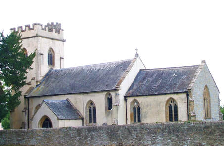
4 (GR311 245) Go R along the road and after 350m just before a L bend, fork R into Rodwell Lane. After 250m where the hard surface ends, go ahead with care along narrow track (Restricted Byway). After 400m cross a track and a further 600m cross a tarmac track. Go ahead a further 900m to cross the line of the disused Chard Canal(2). Go ahead for 500m along track bending L then R to Thornfalcon church(5) [3.0Km]
5 (GR283 239) Follow track past church to reach a road by the War Memorial. Turn L and follow road for 900m to reach the busy A358 and the bus-stop. For Somerton and Yeovil the stop is to the L, for Taunton across the road [1.1Km]
FOR A SHORTER WALK Distance 5.9 Km/ 3.7 miles
Follow as far as the end of point 1. Immediately after Ham House, take the track on the R (SP Public Bridleway). After 200m at metal gate, follow track to L as it goes between hedges. After 400m, go R through metal pedestrian gate and aim for metal gate in hedge gap slightly to L. Keep hedge on R to a gate and go ahead into enclosed path to reach a track. Turn R and follow to Thornfalcon church (point 5).
For car travellers:
There is a lay-by in the lane opposite the Nags Head, 50m along on the L.
Refreshments:
Rising Sun, Knapp
1 The name Thornfalcon comes from Thorn, and the personal name Fagun (now Falcon) which was the Norman surname of Sir Gilbert of Thorn, whose family were lords of the manor until the 14th century. The manor was bought from the Burridges of Lyme Regis by Nathaniel Batten of Yeovil, founder of a solicitor’s firm of that name.
2 Chard Canal, once part of a plan to link the Bristol Channel with the English Channel in Devon, opened in 1842 and closed in 1866.
3 The River Tone is about 21 miles (34 km) long. It rises in the Brendon Hills to the west of Taunton and flows through Curry and Hay Moors before joining the River Parrett at Burrowbridge.
4 The bridge was constructed as access to Coalharbour House, a 16th century Grade II* listed building
5 The Church of the Holy Cross was built in the 14th century and restored several times. It is Grade I listed.
