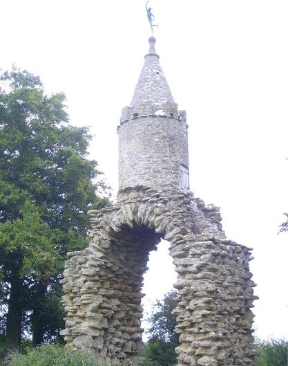
 Jack the Treacle Eater
WALK 12
YEOVIL
(BUS STATION)
The Barwick Park follies and
Ninesprings Country Park
Pleasant rural walking along paths
with gates and stiles
Distance 11.7 Km/ 7.2 miles
Total ascent/descent 133m
www.mapmyrun.com/routes/view/25424959
Updated October 2023 Comments to [email protected]
1 From the bus-stop (GR560 161), leave the bus station past the pub and ahead past the end of Middle Street, then continue ahead past restaurants and cross into Yeo Leisure Park(1). Beyond the last building, go R for 100m then L over wooden bridge. At gate bear 45 degrees L along path climbing to a kissing gate. Go through and R alongside fence climbing steeply with good view of Yeovil(2). Go through kissing gate then bear L to kissing gate next to wooden gate and exit Yeovil Country Park. Go ahead then bear slightly L to gate in line of trees then gate to track and go L, descending [1.0Km]
2 (GR565 150) After 400m beyond houses, go R up steps, through kissing gate and aim slightly L to gate in far corner to reach road. Cross into track (SP Rexe’s Hollow) for 600m to Jack the Treacle Eater(3) with view to Barwick House(4). Continue 200m to Treacle Farm then R to reach stone gateway [1.5Km]
3 (GR562 140) Just beyond, note the view on R to The Rose Tower(4). Follow the road 250m to junction in village and go L, then bear L to school. Go ahead (Southview) ascending and after 250m, bear R into Fairhouse Road. At end of the houses opposite telecom mast, note The Needle (3) over to the R. Go ahead 150m to the A37. Cross to narrow path to R of metal gate, cross stile and go ahead past oak tree to double stile in corner. Cross, bear R 150m with hedge on R to stile at road. Go L 150m and where road bears L go R through gate [2.0Km]
4 (GR557 126) Aim L of first wooden pole to cross ditch, then ascend to stile in far hedge with sleeper bridge. Go ahead parallel to hedge through two metal gates, then to metal gate to L of tree straight ahead. Bear L to take path 150m with wire fence on R. Cross stile and go across large field passing to L of 3 oak trees to cross stile on L just before far corner. Go R on path 120m to track (SP Coker Moor) to reach wider track by water treatment works and after a further 300m, opposite wooden bridge, take waymarked path on R 200m to track junction. Go through metal gate, cross stream and bear slightly R aiming for Bristol gate in far R corner, Go through gate and continue with hedge on R to gate. Cross and go ahead now with hedge on L to reach road by Redlands. After 150m go sharp L and at junction go R for 70m [1.7Km]
5 (GR545 137) Go R into enclosed path (SP Dunnocks Lane) for 300m to gate (SP Barwick) and go ahead to join the Monarch’s Way with hedge on R for 250m. At road, go ahead past T-junction and 150m beyond go L along track (SP Bridleway) 800m to road. Go R and after 60m R again into Little Tarrat Lane to the A37. Cross with care into Two Tower Lane and through the first gate on the L. Keep the hedge on R for 850m to reach crossing hedge and go L (but go R through gate and L along road to view the Fish Tower(3) [3.0Km]
6 (GR560 148) Keep hedge on R and after 150m where it ends bear slightly L to descend steeply to reach stream. Continue with stream on L past lake and kids playground. Go ahead on track, past commercial buildings then in front of residences to reach road into Yeo Leisure Park(1). At road, go L to traffic lights then R and follow road round past the pub to the bus station [1.7Km]
FOR A SHORTER WALK Distance 5.1 Km/ 3.2 miles
At end of point 2, go R along drive (SP Two Tower Lane). Take R fork before Barwick House and after100m(110yds) go through kissing gate on R aiming for big tree in middle of field. Go through kissing gate and follow path to road and cross. This is point 6.
For car travellers:
Park (free on Sunday) in Stars Lane or Yeo Leisure Park.
Refreshments:
Bars, cafés and restaurants in Yeovil
1Yeo Leisure Park is built on the site of Yeovil Town station which was on the GWR line to Taunton, with links to Pen Mill and Yeovil Junction stations. It was closed in 1966
2 Yeovil was first mentioned in the 9th century and granted a charter in 1205. It became the centre of the glove-making industry in the 19th century. In 20th century it has become a centre of aircraft and defence industries.
3 The four follies in Barwick Park said to have been built to give labourers work during the 1820s depression. But paintings of Barwick House in the 1780s include only two of the follies. They were possibly commissioned to mark the park boundaries:- Jack the Treacle Eater (a stone arch topped by a round tower) to the east, the Fish Tower in the north, Messiter's Cone (the Rose Tower) in the west and the Needle to the south. All are listed Grade II
4 Barwick House (listed Grade II) was built around 1770 and remodelled for glove maker George Messiter in 1830.
